On this page
Location
The Thompsons Road precinct is generally defined by Thompsons Road in the north and Hardys Road in the south; and from Berwick-Cranbourne Road in the west to Smiths Lane and Pound Road in the east.
Precinct characteristics
Thompsons Road is both a residential and an employment precinct. The precinct will be a community that integrates business investment with high quality residential development. Characterised by a strong natural ridgeline, extensive views and proximity to Cardinia Creek, a distinct elevated urban amenity will be created as the area develops.
Precinct structure plan
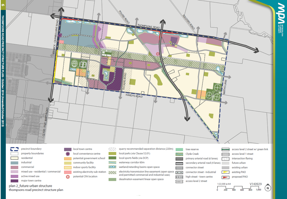
The Future Urban Structure Plan below demonstrates how the precinct will be developed over time. It identifies the location of roads, housing, employment and local parks.

Quick facts
- Area covered by the Precinct Structure Plan - approximately 694 hectares
- Estimated number of dwellings - 6,500 homes
- Estimated future population - 18,200 people
- Estimated number of local jobs - over 8,900 jobs.
Infrastructure funding
Infrastructure within the precinct will be funded by contributions from landowners. The Clyde Development Contributions Plan (DCP) applies to the Thompsons Road PSP. The Clyde Development Contributions Plan (DCP):
- identifies the location for schools, community facilities local parks and roads
- establishes a framework for the collection of funding for infrastructure and services
- ensure the cost is shared between the various developers and the wider community
More information
Further information about the Thompsons Road precinct can be found in the following documents:
- Thompsons Road Precinct Structure Plan
- Clyde Development Contribution Plan.
Access these documents from the Victorian Planning Authority website.
For any further inquiries, please contact the Growth and Investment Department:
- via phone –9705 5200
- via email – caseycc@casey.vic.gov.au
